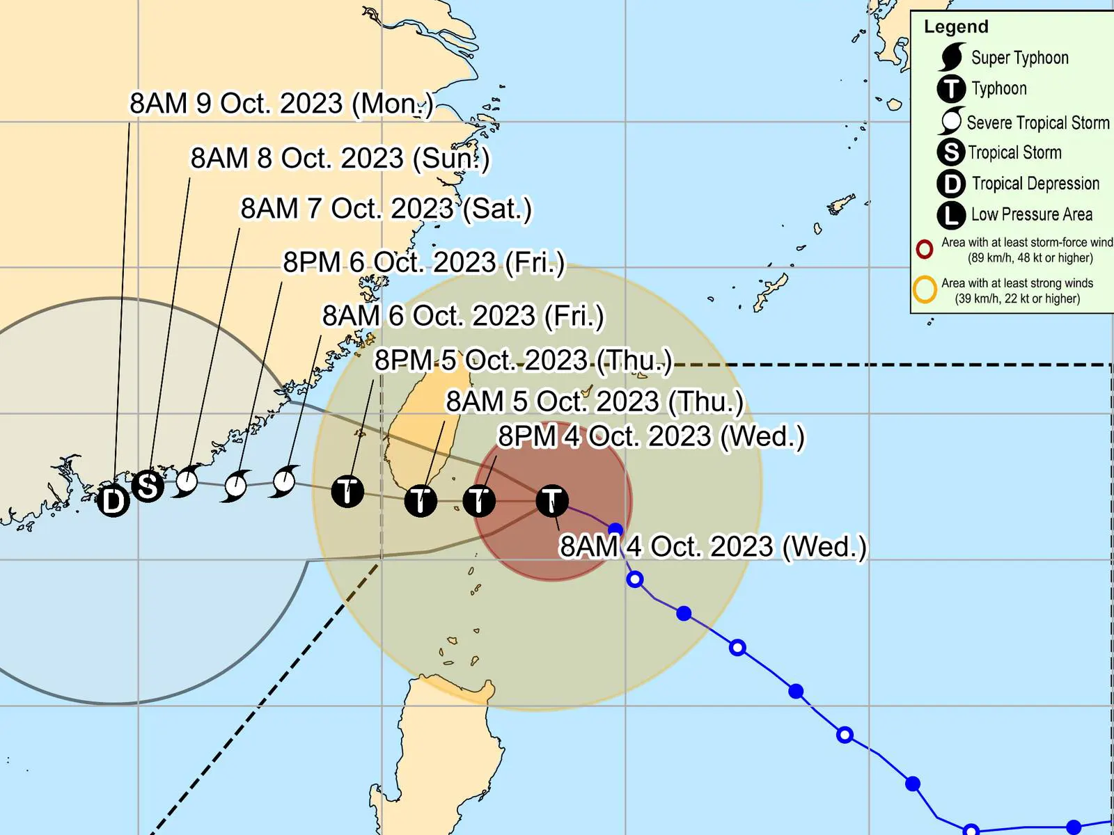
THE state weather bureau Pagasa said Wednesday the center of the eye of Typhoon Jenny was estimated based on all available data at 210 km Northeast of Itbayat, Batanes (22.1°N, 123.3°E)
•Intensity
Maximum sustained winds of 150 km/h near the center, gustiness of up to 185 km/h, and central pressure of 955 hPa
•Present Movement
West Northwestward at 15 km/h
•Extent of Tropical Cyclone Winds
Strong to typhoon-force winds extend outwards up to 560 km from the center
TROPICAL CYCLONE WIND SIGNALS (TCWS) IN EFFECT
TCWS No. 3 Wind threat: Storm-force winds
Warning lead time: 18 hours
Range of wind speeds: 89 to 117 km/h (Beaufort 10 to 11)
Potential impacts of winds: Moderate to significant threat to life and property
Luzon: The northern portion of Batanes (Itbayat)
TCWS No. 2 Wind threat: Gale-force winds
Warning lead time: 24 hours
Range of wind speeds: 62 to 88 km/h (Beaufort 8 to 9)
Potential impacts of winds: Minor to moderate threat to life and property
Luzon: The rest of Batanes and the northern portion of Babuyan Islands (Babuyan Is., Calayan Is.)
TCWS No. 1 Wind threat: Strong winds
Warning lead time: 36 hours
Range of wind speeds: 39 to 61 km/h (Beaufort 6 to 7)
Potential impacts of winds: Minimal to minor threat to life and property
Luzon: The rest of Babuyan Islands, the northern portion of mainland Cagayan (Santa Ana, Gonzaga, Buguey, Santa Teresita, Lal-Lo, Camalaniugan, Pamplona, Claveria, Aparri, Ballesteros, Abulug, Allacapan, Sanchez-Mira, Santa Praxedes, Lasam, Gattaran), the northern portion of Apayao (Calanasan, Pudtol, Luna, Santa Marcela, Flora), and the northern portion of Ilocos Norte (Piddig, Bangui, Vintar, Burgos, Pagudpud, Bacarra, Adams, Pasuquin, Carasi, Dumalneg, Laoag City)
HAZARDS AFFECTING COASTAL WATERS
• Under the influence of JENNY, a Gale Warning is in effect for the coastal waters along the seaboards of Northern Luzon. For more information, refer to Gale Warning No. 6 issued at 5:00 AM today.
• In the next 24 hours, JENNY will also bring moderate to rough seas (1.5 to 3.0 m) over the coastal waters of northern Aurora. Mariners of motor bancas and similarly-sized vessels are advised to take precautionary measures while venturing out to sea and, if possible, avoid navigating in these conditions, especially if inexperienced or operating ill-equipped vessels.
TRACK AND INTENSITY OUTLOOK
• JENNY is forecast to move westward for the remainder of the forecast period. On the track forecast, the typhoon will make landfall over the southern portion of Taiwan tomorrow morning, then exit the Philippine Area of Responsibility (PAR) tomorrow afternoon or evening. Outside the PAR region, JENNY will continue to move westward slowly over the Taiwan Strait and the coastal waters of southeastern China.
• The weakening trend is forecast to continue due to the increasing dry air entrainment and vertical wind shear. Land interaction during its passage over the rugged terrain of southern Taiwan will further weaken the typhoon. Once over the Taiwan Strait, additional cool dry air from the north will entrain into JENNY, resulting in continued weakening.
Considering these developments, the public and disaster risk reduction and management offices concerned are advised to take all necessary measures to protect life and property. Persons living in areas identified to be highly or very highly susceptible to these hazards are advised to follow evacuation and other instructions from local officials. For heavy rainfall warnings, thunderstorm/rainfall advisories, and other severe weather information specific to your area, please monitor products issued by your local PAGASA Regional Services Division.
metrosundaily

