
‘PAENG’ is forecast to exit the Philippine Area of Responsibility this afternoon or evening. This tropical cyclone re-intensified into a severe tropical storm at 8:00 AM today. Further intensification is likely within 12 to 24 hours. However, a weakening trend is expected by late Wednesday or on Thursday.
Considering these developments, the public and disaster risk reduction and management offices concerned are advised to take all necessary measures to protect life and property. Persons living in areas identified to be highly or very highly susceptible to these hazards are advised to follow evacuation and other instructions from local officials. For heavy rainfall warnings, thunderstorm/rainfall advisories, and other severe weather information specific to your area, please monitor products issued by your local PAGASA Regional Services Division.
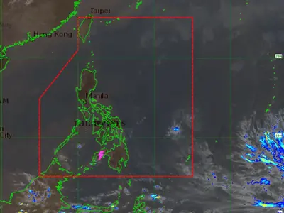
Location of Center (10:00 AM): The center of Severe Tropical Storm “PAENG” was estimated based on all available data at 375 km West of Dagupan City, Pangasinan (16.6°N, 116.9°E)
Intensity: Maximum sustained winds of 95 km/h near the center, gustiness of up to 115 km/h, and central pressure of 985 hPa
Present Movement: Northwestward at 10 km/h
Extent of Tropical Cyclone Winds: Strong to gale-force winds extend outwards up to 650 km from the center
TROPICAL CYCLONE WIND SIGNALS (TCWS) IN EFFECT
TCWS No. 1
Wind threat: Strong winds
Warning lead time: 36 hours
Range of wind speeds: 39 to 61 km/h (Beaufort 6 to 7)
Potential impacts of winds: Minimal to minor threat to life and property
Luzon:
The southern portion of Ilocos Norte (Badoc, Pinili, Banna, Nueva Era, City of Batac, Paoay, Marcos, Currimao, Dingras, Solsona, Sarrat, San Nicolas, Laoag City, Piddig), Ilocos Sur, La Union, Pangasinan, the western and central portions of Pampanga (Mexico, Porac, Angeles City, Santa Rita, Santa Ana, Guagua, Sasmuan, Mabalacat City, Arayat, Santo Tomas, Minalin, City of San Fernando, Bacolor, Floridablanca, Magalang, Lubao), Abra, Benguet, the western portion of Mountain Province (Besao, Tadian, Bauko, Sabangan, Sagada), the western portion of Ifugao (Tinoc, Hungduan), Tarlac, the western portion of Nueva Vizcaya (Santa Fe, Kayapa), the western portion of Nueva Ecija (Cuyapo, Talugtug, Nampicuan, Guimba, Licab, Quezon, Zaragoza, San Antonio, Cabiao), Zambales, and the central and southern portions of Bataan (Orani, Abucay, Hermosa, Samal, Morong, Dinalupihan, Bagac, City of Balanga, Pilar)
Tropical Cyclone Wind Signals in other areas are hereby lifted
HAZARDS AFFECTING LAND AREAS
Heavy Rainfall
• Through this afternoon: Moderate to heavy rains remains possible over Batanes, Zambales, and Bataan. Light to moderate with at times heavy rains still possible over Ilocos Region, Cordillera Administrative Region, Cavite, Batangas, Laguna, the southern portion of Quezon, Western Visayas, Babuyan Islands, MIMAROPA, and the rest of Central Luzon.
• Except in areas with significant antecedent rainfall or those still experiencing persistent heavy rainfall, flooding and rain-induced landslides are likely to slowly subside.
Source: DOST PAGASA