TROPICAL storm Hanna is forecast to move generally west northwestward throughout the forecast period. On the track forecast, the tropical cyclone is forecast to pass close or make landfall in the vicinity of Yaeyama Islands in the Ryukyu archipelago between tomorrow morning and afternoon, then make landfall or pass close to the northern portion of Taiwan tomorrow evening or on Sunday morning. Hanna is forecast to exit the Philippine Area of Responsibility on Sunday morning.
• Outside the PAR, the tropical cyclone will turn more northwestward as it passes over the Taiwan Strait before making another landfall over mainland China on Sunday afternoon or evening.
• HANNA is forecast to reach typhoon category today. It may also reach its peak intensity tomorrow prior to its close approach or landfall over northern Taiwan. Rapid weakening will then ensue following its landfall over mainland China on Sunday.
Considering these developments, the public and disaster risk reduction and management offices concerned are advised to take all necessary measures to protect life and property. Persons living in areas identified to be highly or very highly susceptible to these hazards are advised to follow evacuation and other instructions from local officials. For heavy rainfall warnings, thunderstorm/rainfall advisories, and other severe weather information specific to your area, please monitor products issued by your local Pagasa Regional Services Division.
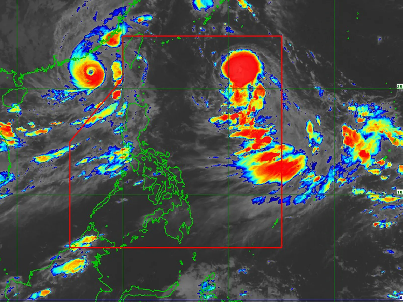
The center of Severe Tropical Storm Hanna was estimated based on all available data at 870 km East of Extreme Northern Luzon (22.1°N, 130.1°E)
Intensity:
Maximum sustained winds of 110 km/h near the center, gustiness of up to 135 km/h, and central pressure of 980 hPa
Present Movement: West Northwestward at 20 km/h
Extent of Tropical Cyclone Winds:
Strong to storm-force winds extend outwards up to 340 km from the center
HAZARDS AFFECTING LAND AREAS
Heavy Rainfall Outlook
HANNA is less likely to directly bring heavy rainfall over the country throughout the forecast period. However, the Southwest Monsoon currently enhanced by Hanna, Super Typhoon Saola (GORING), and Severe Tropical Storm KIROGI will bring occasional to monsoon rains over the western portion of Luzon in the next three days. For more information, refer to Weather Advisory #15 for Southwest Monsoon issued at 11:00 PM yesterday and 24-Hour Public Weather Forecast and Outlook at 4:00 AM today.
Forecast rainfall are generally higher in elevated or mountainous areas. Under these conditions, flooding and rain-induced landslides are expected especially in areas that are highly or very highly susceptible to these hazards as identified in hazard maps and in localities that experienced considerable amounts of rainfall for the past several days.
Severe Winds
Hanna is less likely to directly bring severe winds over the country throughout the forecast period. However, the enhanced Southwest Monsoon will continue to bring gusty conditions over the following areas not under any Wind Signal, especially in coastal and upland/mountainous areas exposed to winds:
• Today: Batanes, Ilocos Region, Cordillera Administrative Region, Zambales, Bataan, Aurora, Bulacan, Metro Manila, CALABARZON, MIMAROPA, Bicol Region, Western Visayas, and the northern portion of Eastern Visayas.
• Tomorrow: Batanes, Ilocos Region, Abra, Benguet, Zambales, Bataan, Bulacan, Aurora, Metro Manila, CALABARZON, MIMAROPA, Bicol Region, Western Visayas, and the northern portion of Eastern Visayas.
• Sunday: Batanes, Ilocos Norte, Ilocos Sur, Zambales, Bataan, Bulacan, Aurora, Metro Manila, CALABARZON, MIMAROPA, Bicol Region, and Western Visayas.
HAZARDS AFFECTING COASTAL WATERS
Hanna is less likely to bring rough sea conditions over any seaboard of the country through the forecast period. However, due to the Southwest Monsoon that it is slightly enhancing, a Gale Warning is in effect for most seaboards of Luzon and Western Visayas, and the seaboard of Northern Samar. Disruption in civilian maritime activities is expected over these areas (e.g., suspension of sea travel) due to hazardous sea condition. For more information, refer to Gale Warning #19 issued at 5:00 AM today.
metrosundaily

