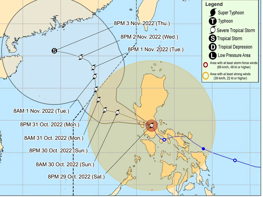
SEVERE Tropical Storm PAENG is forecast to track generally northwestward through Sunday evening and will likely exit the Luzon landmass within 6 to 12 hours.
Afterwards, PAENG will track north northwestward over the West Philippine Sea until Tuesday. On the track forecast, this tropical cyclone may exit the Philippine Area of Responsibility on Monday.
PAENG may maintain its strength from the remainder of its traverse of the Luzon landmass, although the possibility of slight weakening is not ruled out within the next 6 hours. Further re-intensification is likely once PAENG moves over the West Philippine Sea.
Considering these developments, the public and disaster risk reduction and management offices concerned are advised to take all necessary measures to protect life and property. Persons living in areas identified to be highly or very highly susceptible to these hazards are advised to follow evacuation and other instructions from local officials. For heavy rainfall warnings, thunderstorm/rainfall advisories, and other severe weather information specific to your area, please monitor products issued by your local PAGASA Regional Services Division.
“PAENG” HAS PASSED OVER LAGUNA DE BAY AND THE METRO MANILA-RIZAL-BULACAN AREA
• Location of Center (10:00 PM):
The center of Severe Tropical Storm “PAENG” was estimated based on all available data including those from Tagaytay and Subic Doppler Weather Radars in the vicinity of Baliuag, Bulacan (15.0°N, 120.9°E)
• Intensity:
Maximum sustained winds of 95 km/h near the center, gustiness of up to 160 km/h, and central pressure of 985 hPa
• Present Movement:
North northwestward at 15 km/h
• Extent of Tropical Cyclone Winds:
Strong to storm-force winds extend outwards up to 560 km from the center
TROPICAL CYCLONE WIND SIGNALS (TCWS) IN EFFECT
TCWS No. 3
Wind threat: Storm-force winds
Warning lead time: 18 hours
Range of wind speeds: 89 to 117 km/h (Beaufort 10 to 11)
Potential impacts of winds: Moderate to significant threat to life and property
Luzon:
The northern portion of Metro Manila (City of Manila, City of Valenzuela, City of Malabon, City of Navotas, Caloocan City, Quezon City), Bataan, the southern portion of Zambales (San Marcelino, Subic, Olongapo City, Castillejos, San Antonio, San Narciso, San Felipe, Cabangan, Botolan, Palauig, Iba), Pampanga, Bulacan, and the southern portion of Tarlac (Concepcion, Capas, San Jose, Bamban)
TCWS No. 2
Wind threat: Gale-force winds
Warning lead time: 24 hours
Range of wind speeds: 62 to 88 km/h (Beaufort 8 to 9)
Potential impacts of winds: Minor to moderate threat to life and property
Luzon:
Pangasinan, the southern portion of Aurora (San Luis, Baler, Dingalan, Maria Aurora), the rest of Tarlac, Nueva Ecija, the rest of Zambales, Laguna, Batangas, the northern and central portions of Quezon (Alabat, Perez, Plaridel, Atimonan, Unisan, Agdangan, Padre Burgos, Pagbilao, Sariaya, Lucena City, San Antonio, Tiaong, Candelaria, Dolores, City of Tayabas, Lucban, Sampaloc, Mauban, General Nakar, Infanta, Real) including Pollilo Islands, Rizal, Cavite, the rest of Metro Manila, Cavite, the northern portion of Oriental Mindoro (Victoria, Naujan, San Teodoro, Baco, Puerto Galera, City of Calapan), and the northern portion of Occidental Mindoro (Santa Cruz, Abra de Ilog, Mamburao, Paluan) including Lubang Islands
TCWS No. 1
Wind threat: Strong winds
Warning lead time: 36 hours
Range of wind speeds: 39 to 61 km/h (Beaufort 6 to 7)
Potential impacts of winds: Minimal to minor threat to life and property
Luzon:
La Union, Kalinga, Abra, Benguet, Ifugao, Ilocos Sur, Mountain Province, Nueva Vizcaya, Quirino, Isabela, the rest of Aurora, the rest of Quezon, Catanduanes, Camarines Sur, Camarines Norte, Albay, Sorsogon, the western portion of Masbate (Milagros, Mobo, Uson, City of Masbate, Aroroy, Balud, Mandaon, Baleno) including Burias and Ticao Islands, the rest of Occidental Mindoro, the rest of Oriental Mindoro, Palawan (El Nido, Taytay) including Calamian Islands, Cuyo Islands, Romblon, and Marinduque
Visayas:
Capiz, Aklan, and the northern portion of Antique (Barbaza, Culasi, Tibiao, Sebaste, Libertad, Bugasong, Laua-An, Pandan) including Caluya Islands
Tropical Cyclone Wind Signals in other areas are hereby lifted
President Ferdinand R. Marcos Jr. on Saturday expressed disappointment and sought an explanation from government offices after 45 people were reported to have died from the onslaught of Severe Tropical Storm “Paeng” in Maguindanao.
“I would like to start with the flooding in Maguindanao simply because we have to already look at it dahil ang daming casualty,” the President said as he virtually presided over the full council meeting of the National Disaster Risk Reduction and Management Council (NDRRMC)
“It will be important to us to look back and see why this happened na hindi natin naagapan ito,” he said, adding that the number seems very high for a flooding incident.
The chief executive expressed concern over the number of individuals who perished in Maguindanao due to landslides and flashfloods caused by the storm.
“I’m a little bit concerned why the situation in Maguindanao was so bad; let’s study it further, Sec. Solidum, and we’ll find what we can do para mas maging accurate ang mga forecast natin especially sa flooding ‘cause that seems to be the problem now,” said Marcos, referring to Department of Science and Technology (DOST) Secretary Renato Solidum Jr.
“We could have done better in Maguindanao in terms of preparing because… the 40 deaths with 10 people missing is a little too high. We should have done better than that,” the President pointed out.
During the meeting, Acting Defense Secretary Jose Faustino Jr. clarified that the report coming from the Bangsamoro Autonomous Region in Muslim Mindanao (BARMM) was “initially as 67 for validation.”
“They conducted a meeting this morning in the BARMM area and they have corrected the figure from 67 to 40,” Faustino said.
The President has earlier instructed national government agencies to assist the BARMM in its relief and rescue operations on the recent flooding in Maguindanao.
On the instruction of the chief executive, the Department of Social Welfare and Development said that the government has available overall relief resources of P1.5 billion with P445.2 million standby funds and quick response fund (QRF)
metrosundaily

