THE weather bureau said Saturday that tropical cyclone wind signal No. 1 was raised over some parts of Cagayan and Isabela as Super Typhoon Betty (international name: Mawar) maintained its strength while moving west northwestward.
In its 11 a.m. bulletin, Pagasa said the following areas were under TCWS No.1:
the eastern portion of Cagayan (Santa Ana, Gonzaga, Lal-Lo, Gattaran, Baggao, Peñablanca, Santa Teresita, Buguey) including Babuyan and Camiguin Islands; and
the eastern portion of Isabela (Maconacon, Divilacan, Dinapigue, Palanan, San Mariano, Ilagan City, Tumauini, San Pablo, Cabagan).
According to Pagasa, strong winds are of minimal to minor threat to life and property under TCWS No. 1.
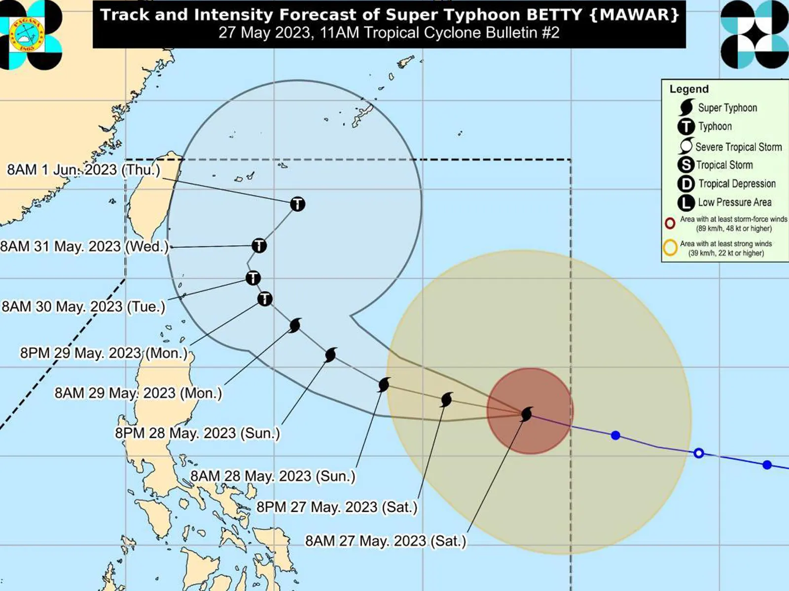
As of 10 a.m., the center of the eye of Super Typhoon Betty was estimated based on all available data at 1,170 km east of Central Luzon (16.4°N, 133.1°E).
Moving west northwestward at 30 km/h, Betty has maximum sustained winds of 195 km/h near the center, gustiness of up to 240 km/h, and central pressure of 915 hPa.
Forecast accumulated rainfall from Monday morning to Tuesday morning will be 50-100 mm in Batanes, Babuyan Islands, and the northern portions of mainland Cagayan, Ilocos Norte, and Apayao.
Meanwhile, from Tuesday morning to Wednesday morning, the forecast accumulated rainfall will be greater than 200 mm in Batanes; 100-200 mm in Babuyan Islands, Ilocos Norte, Ilocos Sur, and La Union; and 50-100 mm in Cordillera Administrative Region and the northern portion of mainland Cagayan.
Pagasa said forecast rainfall are generally higher in elevated or mountainous areas.
Monsoon rains
For areas that will not be directly affected by the super typhoon, monsoon rains from the enhanced Southwest Monsoon will be possible over the western sections of MIMAROPA, Visayas, and Mindanao on Sunday.
On Monday and Tuesday, monsoon rains will be likely over the western sections of MIMAROPA and Western Visayas, and possible over the rest of MIMAROPA and Western Visayas.
“Under these conditions, flooding and rain-induced landslides are likely, especially in areas that are highly or very highly susceptible to these hazard as identified in hazard maps and in localities that experienced considerable amounts of rainfall for the past several days,” Pagasa said.


