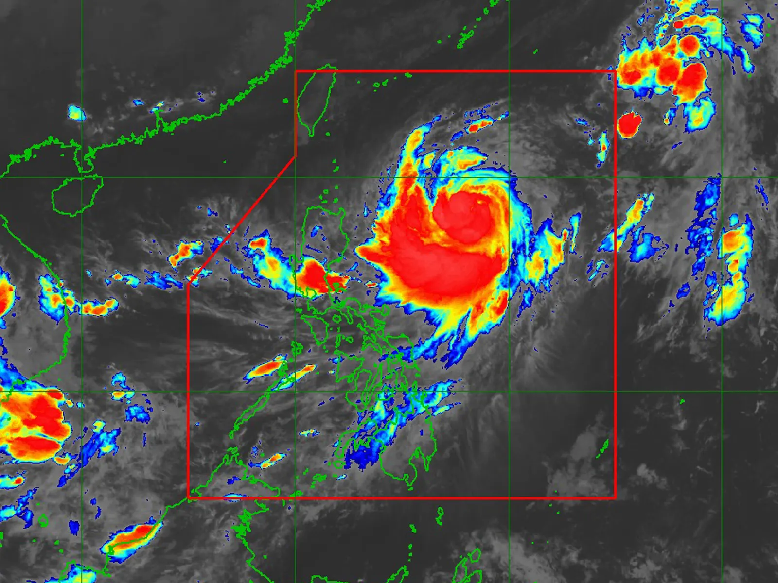
STATE weather bureau said the center of Severe Tropical Storm Jenny was estimated based on all available data at 715 km East of Aparri, Cagayan (18.4°N, 128.4°E)
Intensity: Maximum sustained winds of 110 km/h near the center, gustiness of up to 135 km/h, and central pressure of 980 hPa
Present Movement: Northwestward at 10 km/h
Extent of Tropical Cyclone Winds: Strong to storm-force winds extend outwards up to 560 km from the center
TROPICAL CYCLONE WIND SIGNALS (TCWS) IN EFFECT
TCWS No. 1
Wind threat: Strong winds
Warning lead time: 36 hours
Range of wind speeds: 39 to 61 km/h (Beaufort 6 to 7)
Potential impacts of winds: Minimal to minor threat to life and property
Luzon
– Batanes
HAZARDS AFFECTING LAND AREAS
Heavy Rainfall Outlook
Forecast accumulated rainfall from tomorrow evening to Tuesday evening
• 50-100 mm: Batanes, Babuyan Islands, the northern and eastern portion of mainland Cagayan, and the eastern portion of Isabela
Forecast accumulated rainfall from Tuesday evening to Wednesday evening
• 100-200 mm: Batanes
• 50-100 mm: Babuyan Islands, and the northern portions of mainland Cagayan, Apayao, and Ilocos Norte.
In addition, JENNY will continue to enhance the Southwest Monsoon and bring occasional to monsoon rains over the western portions of Central Luzon, Southern Luzon, Visayas, and Mindanao in the next 3 days. For more information, refer to Weather Advisory No. 3 for Southwest Monsoon issued at 11:00 PM today
Forecast rainfall are generally higher in elevated or mountainous areas. Under these conditions, flooding and rain-induced landslides are possible especially in areas that are highly or very highly susceptible to these hazards as identified in hazard maps and in localities that experienced considerable amounts of rainfall for the past several days.
Severe Winds
The wind signals warn the public of the general wind threat over an area due to the tropical cyclone. Local winds may be slightly stronger/enhanced in coastal and upland/mountainous areas exposed to winds. Winds are less strong in areas sheltered from the prevailing wind direction.
• Minimal to minor impacts from strong winds are possible within any of the areas under Wind Signal No. 1.
The enhancement of the Southwest Monsoon by JENNY will bring gusty conditions for the next 3 days over the following areas not under any Wind Signal, especially in coastal and upland/mountainous areas exposed to winds:
• Tonight through tomorrow: Most of MIMAROPA, Western Visayas, and Bicol Region
• Tuesday: Metro Manila, CALABARZON, MIMAROPA, Bicol Region, and Western Visayas
• Wednesday: Bataan, the southern portion of Aurora, Metro Manila, CALABARZON, the northern portion of Palawan including Calamian Islands, Romblon, Occidental Mindoro, and portions of Bicol Region.
HAZARDS AFFECTING COASTAL WATERS
Tomorrow, JENNY will bring moderate to rough seas (2.0 to 4.0 m) over the coastal waters of Extreme Northern Luzon and the northern portion of mainland Cagayan. Mariners of motor bancas and similarly-sized vessels are advised to take precautionary measures while venturing out to sea and, if possible, avoid navigating in these conditions, especially if inexperienced or operating ill-equipped vessels. Furthermore, there is a high possibility of hoisting a Gale Warning for these coastal waters as well.
TRACK AND INTENSITY OUTLOOK
• JENNY is forecast to move generally northwestward until Tuesday morning before turning west northwestward on Wednesday and generally westward thereafter. On the track forecast, JENNY will make landfall over the southern portion of Taiwan on Thursday afternoon or evening then exit the Philippine Area of Responsibility (PAR) over the Taiwan Strait between Thursday evening or Friday morning. A landfall or close approach scenario over the Batanes area is still not ruled out since these scenarios are within the forecast confidence cone.
• JENNY is forecast to steadily intensify throughout the forecast period and may reach typhoon category tomorrow morning. Furthermore, it may reach its peak intensity on Tuesday.
Considering these developments, the public and disaster risk reduction and management offices concerned are advised to take all necessary measures to protect life and property. Persons living in areas identified to be highly or very highly susceptible to these hazards are advised to follow evacuation and other instructions from local officials. For heavy rainfall warnings, thunderstorm/rainfall advisories, and other severe weather information specific to your area, please monitor products issued by your local PAGASA Regional Services Division.
metrosundaily

