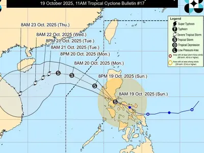
LOCATION of Center (10:00 AM): The center of Tropical Storm DODONG was estimated based on all available data at 305 km West of Sinait, Ilocos Sur (18.1°N, 117.6°E)
Intensity: Maximum sustained winds of 65 km/h near the center, gustiness of up to 80 km/h, and central pressure of 994 hPa
Present Movement: North northwestward at 10 km/h
Extent of Tropical Cyclone Winds: Strong winds extend outwards up to 310 km from the center
TROPICAL CYCLONE WIND SIGNALS (TCWS) IN EFFECT
No Wind Signals hoisted at this time.
HAZARDS AFFECTING LAND AREAS
Heavy Rainfall Outlook
Tropical Storm Dodong does not directly bring heavy rainfall to any part of the country.
For more information on the areas affected by occasional to frequent rains from the Southwest Monsoon enhanced by DODONG refer to the Weather Advisory #6 for Southwest Monsoon issued at 11:00 AM today and the 24-Hour Public Weather Forecast at 4:00 AM today.
Severe Winds
All Wind Signals have been lifted. However, the enhanced Southwest Monsoon may still bring gusty conditions over the following areas (especially in coastal and upland/mountainous areas exposed to winds:
• Today: Ilocos Region, Cordillera Administrative Region, Batanes, the eastern portion of Isabela, Quirino, Nueva Vizcaya, Zambales, Bataan, Bulacan, Pampanga, Aurora, Metro Manila, CALABARZON, MIMAROPA, Bicol Region, and Western Visayas
• Tomorrow: Ilocos Region, Zambales, Bataan, Cavite, MIMAROPA, Bicol Region, Western Visayas, and the southern portion of Quezon.
• Monday: Ilocos Region, Zambales, Bataan, Cavite, Oriental Mindoro, Palawan, Romblon, and Antique.
HAZARDS AFFECTING COASTAL WATERS
Under the influence of DODONG and the enhanced Southwest Monsoon, a marine gale warning is in effect over the northern and western seaboards of Luzon and Western Visayas. For more information, refer to Gale Warning #1 (Intermediate) issued at 11:00 AM today.
TRACK AND INTENSITY OUTLOOK
• DODONG is forecast to move generally northwestward today before turning west northwestward for the remainder of the forecast period. It may exit the Philippine Area of Responsibility (PAR) between this morning or on the afternoon.
• DODONG is forecast to intensify while over the West Philippine Sea. It may steadily intensify and reach typhoon category on Monday.
Considering these developments, the public and disaster risk reduction and management offices concerned are advised to take all necessary measures to protect life and property. Persons living in areas identified to be highly or very highly susceptible to these hazards are advised to follow evacuation and other instructions from local officials. For heavy rainfall warnings, thunderstorm/rainfall advisories, and other severe weather information specific to your area, please monitor products issued by your local PAGASA Regional Services Division.
The next tropical cyclone bulletin will be issued at 5:00 PM today.
DOST-PAGASA