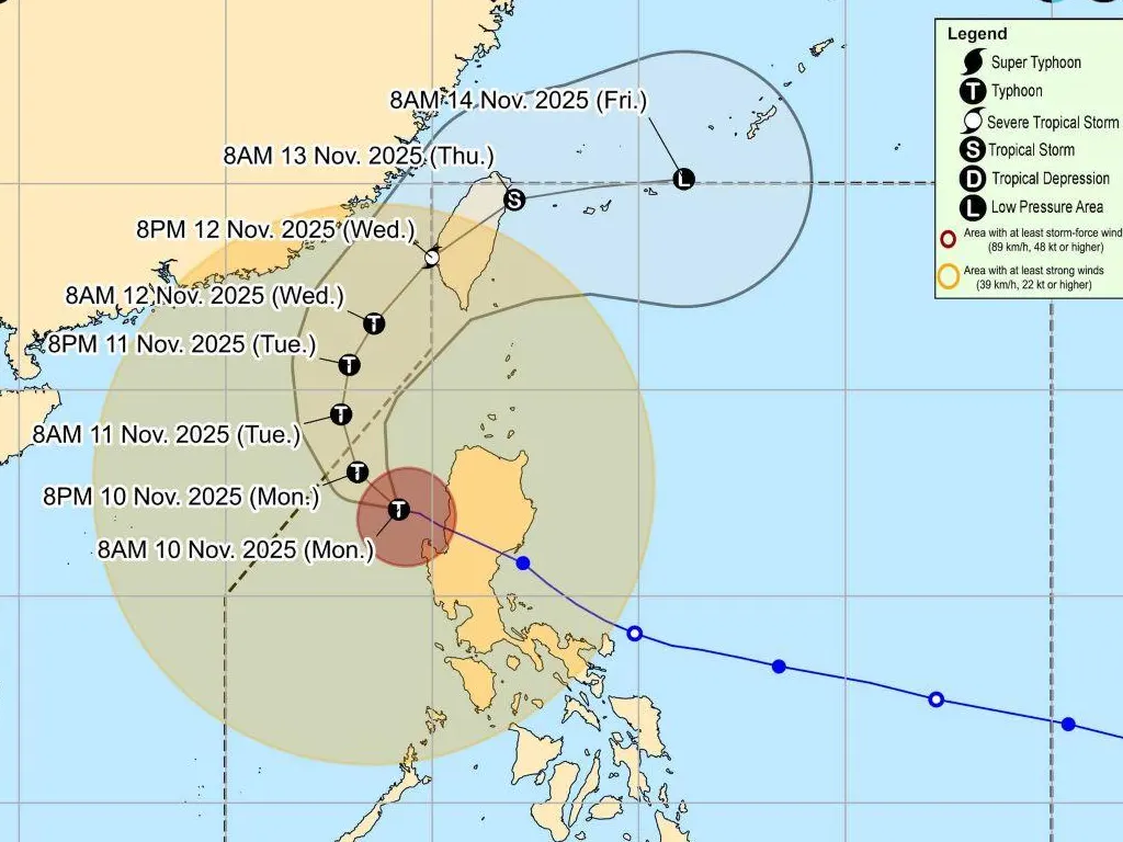
TYPHOON ‘Uwan’ (Fung-wong) continued to weaken as it moved farther over the West Philippine Sea on Monday morning, according to PAGASA.
As of 10 a.m., the center of Uwan was estimated to be located at 135 kilometers west-northwest of Bacnotan, La Union with maximum sustained winds of 130 km/h, gusts of up to 160 km/h, and a central pressure of 970 hPa. Uwan was moving west-northwest at 20 km/h.
Despite weakening, Uwan’s strong to typhoon-force winds extend up to 850 kilometers from its center, affecting large parts of Luzon and portions of the Visayas.
Tropical Cyclone Wind Signals in effect:
- Signal No. 3 (storm-force winds; 89–117 km/h) is in effect over: Ilocos Sur; northern and central portions of La Union; and northwestern portion of Pangasinan.
- Signal No. 2 (gale-force winds; 62–88 km/h) was raised over: Batanes; Cagayan (including Babuyan Islands); Isabela; Quirino; Nueva Vizcaya; Apayao; Abra; Kalinga; Mountain Province; Ifugao; Benguet; Ilocos Norte; rest of La Union; rest of Pangasinan; Aurora; Zambales; Bataan; Nueva Ecija; Tarlac; Pampanga; and Bulacan.
- Signal No. 1 (strong winds; 39–61 km/h) is in effect over: Metro Manila; Cavite; Laguna; Batangas; Rizal; Quezon (including Polillo Islands); Oriental and Occidental Mindoro (including Lubang Island); Marinduque; Romblon; northern Palawan (Taytay, Dumaran, El Nido, Araceli) including Calamian and Cuyo Islands; Camarines Norte; Camarines Sur; Catanduanes; Albay; Sorsogon; northern and western portions of Masbate (including Burias and Ticao Islands); Aklan; Capiz; and northern and central portions of Antique (including Caluya Islands).
PAGASA warned that storm-force winds may cause moderate to significant impacts in areas under Signal No. 3, while gale-force and strong winds will bring minor to moderate impacts in areas under Signal Nos. 2 and 1. Outside signal areas, Uwan will still bring gusty conditions over Palawan, Visayas, Zamboanga Peninsula, Northern Mindanao, and parts of Davao Region today.
There is also a high risk of life-threatening storm surges exceeding 3 meters in low-lying coastal areas of the Ilocos Region, Cagayan Valley, Central Luzon, Metro Manila, CALABARZON, MIMAROPA, Aklan, and Antique. Meanwhile, a gale warning is in effect across the seaboards of northern and central Luzon and the western seaboard of Southern Luzon, where sea heights may reach up to 8 meters, making sea travel extremely dangerous for all types of vessels.
PAGASA said Uwan is forecast to recurve northwestward today, turn northward by Tuesday (November 11), and northeastward thereafter. The typhoon is expected to exit the Philippine Area of Responsibility (PAR) by late Monday night or early Tuesday morning, but could re-enter by Wednesday evening as it moves toward Taiwan and the Ryukyu Islands, eventually weakening into a remnant low by Friday.
Residents in areas under wind signals and coastal communities at risk of storm surges are urged to remain alert and heed evacuation orders from local authorities. Mariners are strongly advised not to venture out to sea until weather conditions improve.