HAZARDS AFFECTING LAND AREAS
Heavy Rainfall Outlook
Forecast accumulated rainfall from today to tomorrow afternoon
50-100 mm: Ilocos Norte, Ilocos Sur, La Union, Pangasinan, and the western portions of Abra and Benguet
Forecast rainfall are generally higher in elevated or mountainous areas. Under these conditions, flooding and rain-induced landslides are highly likely especially in areas that are highly or very highly susceptible to these hazards as identified in hazard maps and in localities that experienced considerable amounts of rainfall for the past several days.
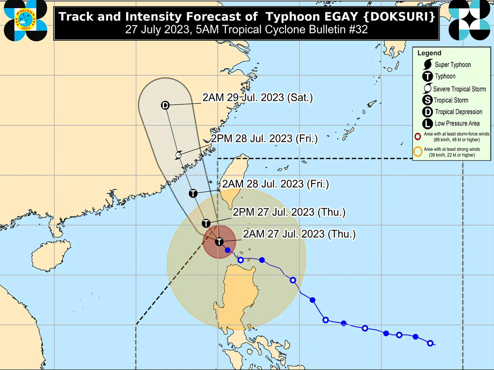
The Southwest Monsoon enhanced by EGAY will continue to bring occasional to monsoon rains over the western portions of Central Luzon and Southern Luzon in the next three days. For more information, refer to Weather Advisory #9 for Southwest Monsoon issued at 11:00 PM yesterday and the 24-Hour Public Weather Forecast and Outlook at 4:00 AM today.
Severe Winds
Minor to moderate impacts from gale-force winds are possible within any of the areas where Wind Signal No. 2 is in effect. Minimal to minor impacts from strong winds are also possible within any of the areas where Wind Signal No.1 is hoisted.
The wind signals warn the public of the general wind threat over an area due to the tropical cyclone. Local winds may be slightly stronger/enhanced in coastal and upland/mountainous areas exposed to winds. Winds are less strong in areas sheltered from the prevailing wind direction.
The enhanced Southwest Monsoon will continue to bring gusty conditions over the following areas not under any Wind Signal, especially in coastal and upland/mountainous areas exposed to winds:
Today: Luzon and Western Visayas
Tomorrow: Batanes, Ilocos Region, Zambales, Bataan, Cavite, the southern portion of Quezon, MIMAROPA, Bicol Region, and Western Visayas
Saturday: Zambales, Bataan, Cavite, Romblon, the northwestern portion of Antique, and Kalayaan Islands.
Coastal Inundation
There is a moderate to high risk of storm surge which may cause flooding in the low-lying and exposed coastal areas of Batanes, the northwestern portion of Cagayan including Babuyan Islands, Ilocos Norte, and extreme northern portion of Ilocos Sur. Maximum surge heights may reach 3.0 m some of the warning areas. For more information, refer to Storm Surge Warning #13 issued at 2:00 AM today.
HAZARDS AFFECTING COASTAL WATERS
Under the influence of EGAY and the enhanced Southwest Monsoon, a Gale Warning is in effect over several coastal waters along the seaboards of Luzon and the eastern and western seaboards of Visayas. For more information, refer to Gale Warning #9 issued at 5:00 AM today.
Rough to high or very high seas: Sea travel is risky for most vessels. All mariners are advised to remain in port or seek safe harbor until winds and waves subside.
Rough to very rough seas: Sea travel is risky for small seacrafts. For larger vessels, operating in gale conditions requires experience and properly equipped vessels. Mariners without proper experience or operating ill-equipped vessels are advised to remain in port or seek safe harbor. DOST-PAGASA