THE government is closely monitoring Tropical Depression Odette which, according to weather forecasters, will likely enter the Philippine Area of Responsibility as a severe tropical storm on the evening of December 14.
The National Disaster Risk Reduction and Management Council is already making the necessary preparations in coordination with the regional and local disaster risk reduction and management councils to ensure the safety of the public.
The Department of Social Welfare and Development (DSWD) reports that as of Sunday, December 12, it has available stockpiles and standby funds earmarked for disaster response.
We ask everyone, especially those residing in affected areas, to keep up to date with the latest weather advisories and bulletins, to take precautionary measures, and to cooperate with local authorities should there be a need for evacuation or other necessary actions.
The weather bureau on Sunday, December 12, warned the Visayas, much of Mindanao, and parts of Southern Luzon to brace for an incoming tropical cyclone that could bring heavy rain and fierce winds.
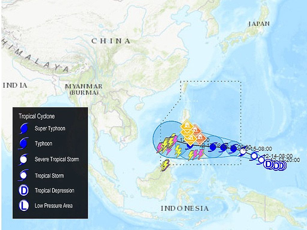
As of Sunday evening, the Philippine Atmospheric, Geophysical, and Astronomical Services Administration (PAGASA) was monitoring a tropical depression located outside the Philippine Area of Responsibility (PAR).
The tropical depression was last spotted 1,975 kilometers east of Mindanao, moving west at 15 kilometers per hour (km/h).
At the moment, it has maximum sustained winds of 55 km/h and gustiness of up to 70 km/h, but PAGASA expects the tropical depression to gradually intensify in the coming days.
The tropical depression could enter PAR as a severe tropical storm by Tuesday evening, December 14. It will be given the local name Odette once inside PAR.
Areas in the eastern portions of the Visayas and Mindanao might be placed under Signal No. 1 as early as Tuesday afternoon or evening, according to PAGASA.
Eventually, other areas in the Visayas, large parts of Mindanao, and several provinces in Southern Luzon may be placed under tropical cyclone wind signals too “due to the threat of strong to typhoon-force winds.” Signal No. 3 would be the highest possible wind signal.
On Wednesday, December 15, the potential Odette could strengthen into a typhoon. PAGASA sees it reaching a peak intensity of around 150 km/h before landfall.
It could make landfall in Eastern Visayas or Caraga by Thursday afternoon or evening, December 16.
As the tropical cyclone hits land and passes through the central Philippine islands, heavy rainfall is expected to hit the same areas where tropical cyclone wind signals are likely to be raised.
“Coastal inundation due to high waves near the coast and storm surges are also possible for low-lying localities near and along the path” of the tropical cyclone, PAGASA warned.