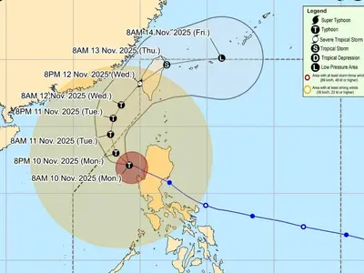
TROPICAL Storm Marce slightly intensified and its trough is expected to bring rains over the extreme Northern Luzon and the eastern section of Luzon starting Monday or Tuesday, PAGASA said.
In its 11 am bulletin on Monday, PAGASA also said Marce may enhance the northeasterly wind flow which may occur within the week.
“Tropical Cyclone Wind Signal No. 1 may be hoisted over portions of Cagayan by tomorrow. The highest Wind Signal which may be hoisted during the occurrence of MARCE is Wind Signal No. 4,” PAGASA said.
Due to the northeasterly wind flow, strong to gale-force gusts are expected on Monday in Batanes, Cagayan including Babuyan Islands, Isabela, Ilocos Norte, Aurora, and the northern portion of Quezon.
Rough seas of up to 3.5 meters may be experienced in the seaboards of Batanes, Babuyan Islands, Ilocos Norte, and Ilocos Sur.
“Mariners of small seacrafts, including all types of motorbancas, are advised not to venture out to sea under these conditions, especially if inexperienced or operating ill-equipped vessels,” PAGASA said.
Waves of up to 2.5 meters are expected over the seaboards of mainland Cagayan, Isabela, Aurora, and the northern and eastern seaboards of Polillo Islands, the remaining seaboards of Ilocos Region, the seaboards of Northern Quezon, Camarines Norte, the northern and eastern seaboards of Catanduanes, the eastern seaboard of Albay, the eastern seaboard of Sorsogon, Northern Samar, and the eastern seaboard of Eastern Samar.