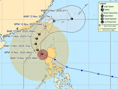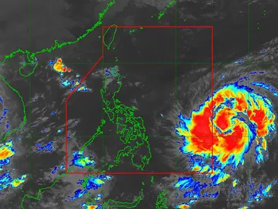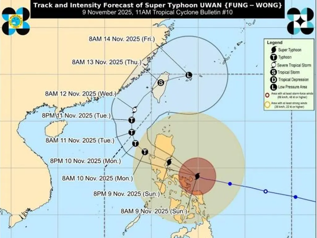
AS of 1:00 PM, the center of the eye of Super Typhoon UWAN was estimated to be 135 km North Northwest of Virac, Catanduanes or 100 km Northeast of Daet, Camarines Norte (14.7°N, 123.7°E). The typhoon has maximum sustained winds of 185 km/h near the center, gustiness of up to 230 km/h, and a central pressure of 935 hPa. It is moving west northwestward at 30 km/h, with strong to typhoon-force winds extending outwards up to 900 km from the center.
Tropical Cyclone Wind Signal (TCWS) No. 5 is in effect over the southern portion of Quirino, the southeastern portion of Nueva Vizcaya, the northeastern portion of Nueva Ecija, the central portion of Aurora, Polillo Islands, the northern portion of Camarines Norte, the northern and eastern portions of Camarines Sur, and the northern portion of Catanduanes. These areas are expected to experience typhoon-force winds, posing an extreme threat to life and property.
TCWS No. 4 is in effect over the southern portion of Isabela, the rest of Quirino, the rest of Nueva Vizcaya, the southern portion of Ifugao, Benguet, the southern portion of Ilocos Sur, La Union, Pangasinan, the rest of Aurora, the rest of Nueva Ecija, the northernmost portion of Zambales, the northeastern portion of Tarlac, the easternmost portion of Pampanga, the eastern portion of Bulacan, the northern portion of Rizal, the northern and eastern portions of Quezon, the rest of Camarines Norte, the rest of Camarines Sur, the northeastern portion of Albay, and the rest of Catanduanes. These areas are expected to experience typhoon-force winds, posing a significant to severe threat to life and property.
TCWS No. 3 is in effect over the southern portion of mainland Cagayan, the rest of Isabela, the central and southern portions of Apayao, Abra, Kalinga, Mountain Province, the rest of Ifugao, the southern portion of Ilocos Norte, the rest of Ilocos Sur, the rest of Zambales, Bataan, the rest of Tarlac, the rest of Pampanga, the rest of Bulacan, Metro Manila, Cavite, Batangas, the rest of Rizal, Laguna, the rest of Quezon, Marinduque, the rest of Albay, Sorsogon, Ticao and Burias Islands, and Northern Samar. These areas are expected to experience storm-force winds, posing a moderate to significant threat to life and property.
TCWS No. 2 is in effect over the rest of Cagayan including Babuyan Islands, the rest of Apayao, the rest of Ilocos Norte, Occidental Mindoro including Lubang Islands, Oriental Mindoro, Romblon, the rest of Masbate, Eastern Samar, Samar, Biliran, and the northern and central portions of Leyte. These areas are expected to experience gale-force winds, posing a minor to moderate threat to life and property.
TCWS No. 1 is in effect over Batanes, the northern portion of Palawan including Calamian, Cuyo, and Cagayancillo Islands, the rest of Leyte, Southern Leyte, Bohol, Cebu including Bantayan and Camotes Islands, Negros Oriental, Negros Occidental, Siquijor, Guimaras, Iloilo, Capiz, Aklan, Antique, Dinagat Islands, Surigao del Norte, the northern portion of Agusan del Norte, and the northern portion of Surigao del Sur. These areas are expected to experience strong winds, posing a minimal to minor threat to life and property.
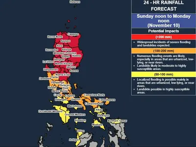
The public and disaster risk reduction and management offices concerned are advised to take all necessary measures to protect life and property. Persons living in areas identified to be highly or very highly susceptible to these hazards are advised to follow evacuation and other instructions from local officials.