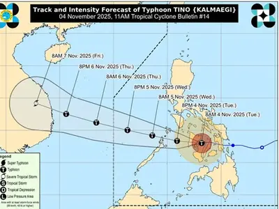
TYPHOON “Tino” has intensified as it continues to move west northwestward over the West Philippine Sea, according to the latest update from PAGASA issued at 10:00 PM.
The center of the eye of Typhoon TINO was estimated based on all available data at 225 km Northeast of Pag-asa Island, Kalayaan, Palawan (12.6°N, 115.6°E). The typhoon has maximum sustained winds of 150 km/h near the center, gustiness of up to 185 km/h, and a central pressure of 965 hPa. It is moving west northwestward at 25 km/h, with strong to typhoon-force winds extending outwards up to 560 km from the center.
Tropical Cyclone Wind Signal (TCWS) No. 2 is in effect over the Kalayaan Islands, indicating gale-force winds with potential minor to moderate threat to life and property. TCWS No. 1 is in effect over the rest of Palawan including Calamian Islands, indicating strong winds with potential minimal to minor threat to life and property.
Severe Winds: The wind signals warn the public of the general wind threat over an area due to the tropical cyclone. Local winds may be slightly stronger/enhanced in coastal and upland/mountainous areas exposed to winds. Winds are less strong in areas sheltered from the prevailing wind direction. Minor to moderate impacts from gale-force winds are possible within any of the localities where Wind Signal No. 2 is hoisted. Minimal to minor impacts from strong winds are possible within any of the areas under Wind Signal No. 1. Furthermore, the weakening surge of the Northeast Monsoon and the outer rainbands of TINO will also bring strong wind gusts over the following areas not under Wind Signal (especially in coastal and upland areas exposed to winds): Batanes, Babuyan Islands, Ilocos Norte, Zambales, Bataan, Batangas, Occidental Mindoro, Oriental Mindoro, Marinduque, Romblon, and Antique.
Hazards Affecting Coastal Waters: A Gale Warning is in effect over the seaboards of Kalayaan Islands. Up to very rough seas are expected over the seaboards of Kalayaan Islands (up to 5.0 m), making sea travel risky for all types or tonnage of vessels. Mariners must remain in port or seek shelter as soon as possible. Up to rough seas are expected over the western seaboards of Palawan including Calamian Islands (up to 3.5 m) and the seaboards of Batanes, Babuyan Islands, and Ilocos Norte; the northwestern seaboard of Occidental Mindoro including Lubang Islands (up to 3.0 m). Mariners of small seacrafts are advised not to venture out to sea under these conditions.
Track and Intensity Outlook: On the forecast track, TINO will continue moving west northwestward over the West Philippine Sea and exit the Philippine Area of Responsibility tonight or tomorrow (06 November) early morning. TINO will continue to intensify and may reach its peak intensity while over the West Philippine Sea.
The public and disaster risk reduction and management offices are advised to take all necessary measures to protect life and property. Persons living in areas identified to be highly or very highly susceptible to these hazards are advised to follow evacuation and other instructions from local officials.