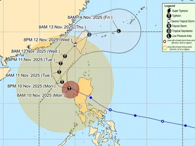
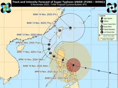
THE weather bureau said Typhoon Hinnamnor continues to intensify outside the Philippine area of responsibility (PAR).
In its 5 a.m. tropical cyclone advisory, PAGASA said Hinnamnor was last seen 1,830 km east northeast of extreme northern Luzon. It has maximum sustained winds of 165 kph near the center and gustiness of up to 205 kph.
It is moving westward at 35 kph.
Hinnamnor may enter the PAR Wednesday evening, at which point it will be named Gardo, according to the state weather bureau. It is expected to slow down as it turns more southwestward over the northern Philippine Sea.
By late Friday (September 2) or early Saturday (September 3), Hinnamnor may become almost stationary, PAGASA said.
The extent of Hinnamnor’s tropical cyclone winds may continue to expand in the coming days as it moves towards the northern Philippine Sea. As such, tropical cyclone wind signals may be raised over extreme northern Luzon.
The typhoon may also bring rough seas over the northern and eastern seaboard of Luzon beginning late Thursday (September 1) or early Friday.