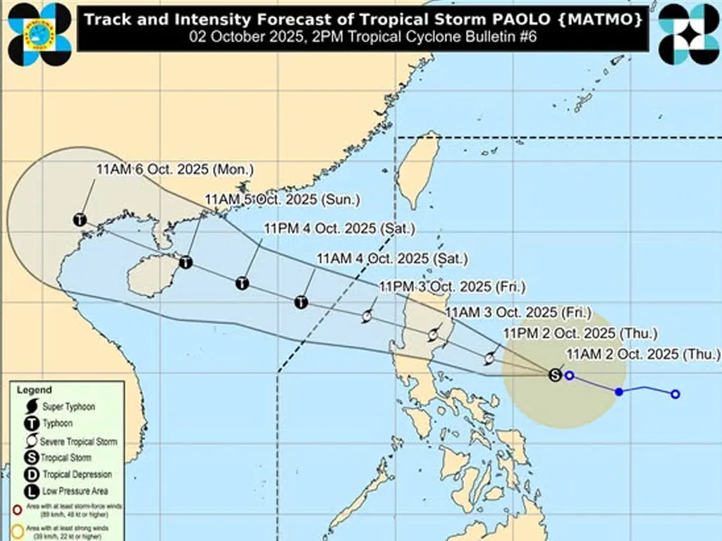
TROPICAL Storm “Paolo” is maintaining its strength as it moves westward over the Philippine Sea, prompting the hoisting of Tropical Cyclone Wind Signals in several areas of Luzon.
As of 1:00 PM, the center of “Paolo” was estimated to be 530 km East of Infanta, Quezon, packing maximum sustained winds of 75 km/h near the center and gustiness of up to 90 km/h. It is moving westward at 20 km/h.
Tropical Cyclone Wind Signal No. 2 is in effect over the central and southern portions of Isabela, the northern portion of Quirino and Nueva Vizcaya, the eastern portion of Mountain Province, Ifugao, and the northern portion of Aurora, warning of gale-force winds.
Tropical Cyclone Wind Signal No. 1 is raised over Cagayan, the rest of Isabela, Quirino, Nueva Vizcaya, Apayao, and several other provinces in Luzon, signaling strong winds. PAGASA warns of a moderate to high risk of life-threatening storm surge in the low-lying coastal areas of Ilocos Norte, Cagayan, Isabela, Aurora, Quezon, Camarines Norte, Camarines Sur, and Catanduanes.
“Paolo” is forecast to make landfall over southern Isabela or northern Aurora tomorrow morning (October 3rd) and may reach severe tropical storm category tonight.
While intensification into a typhoon before landfall is not ruled out, it is highly likely once “Paolo” emerges over the West Philippine Sea. The public and disaster risk reduction and management offices are advised to take all necessary measures to protect life and property, and those in high-risk areas are urged to follow evacuation orders from local officials.