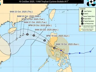
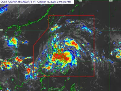
TROPICAL Storm “Opong” has further intensified as it moves west southwestward over the Philippine Sea, prompting the raising of Tropical Cyclone Wind Signal (TCWS) No. 1 in several areas of Visayas.
As of 10:00 AM today, the center of “Opong” was estimated to be 815 km east of Northeastern Mindanao (9.7°N, 132.9°E), packing maximum sustained winds of 85 km/h near the center and gustiness of up to 105 km/h. The storm is moving west southwestward at 15 km/h with a central pressure of 996 hPa.
TCWS No. 1 is currently in effect over Northern Samar, Eastern Samar, and Samar in the Visayas region, indicating a threat of strong winds with potential minimal to minor impacts on life and property.
Strong to gale-force gusts are also expected over Ilocos Region, Cordillera Administrative Region, Batanes, Cagayan including Babuyan Islands, Isabela, Zambales, Bataan, Tarlac, Pampanga, Nueva Ecija, Bulacan, Metro Manila, Cavite, Batangas, Quezon, MIMAROPA, Western Visayas, Negros Island Region, Zamboanga del Norte, Misamis Occidental, Misamis Oriental, Camiguin, Agusan del Norte, Surigao del Norte, Dinagat Islands, Sarangani, Davao del Sur, and Davao Oriental. PAGASA warns of potential coastal flooding due to storm surge in low-lying coastal areas of Southern Luzon and Eastern Visayas.
“Opong” is forecast to move west northwestward, potentially making landfall over the Bicol Region by Friday afternoon and crossing Southern Luzon from Friday afternoon until Saturday morning. The storm is expected to intensify further over the Philippine Sea, possibly reaching typhoon category before landfall, and may re-intensify once it emerges over the West Philippine Sea. The public and disaster risk reduction and management offices are advised to take all necessary precautions.