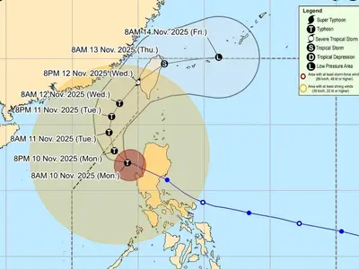
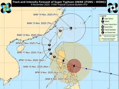
THE weather bureau said on its 11pm bulletin on Friday said super typhoon ‘Mawar’ slightly weakens as it continues to approach the Philippine Area of Responsibility (PAR).
Super Typhoon ‘Mawar’ is forecast to enter the PAR region tomorrow early morning.
On the track forecast, the super typhoon will continue accelerating west northwestward until tomorrow before gradually decelerating on Sunday while maintaining its direction.
On Monday, ‘Mawar’ will move slowly northwestward over the waters east of Batanes and may become almost stationary, then turn north northeastward on Wednesday.
‘Mawar’ is forecast to remain as a super typhoon tonight until the weekend, although the chance of slight weakening still remains.
However, this tropical cyclone may weaken at faster rate beginning on Monday during its slowdown period due to potential unfavorable conditions (e.g., effect of upwelling of cooler ocean water and dry air intrusion), although it is expected to remain as a typhoon by the end of the forecast period.
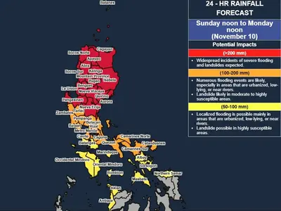
Hazards: Current forecast scenario shows that the typhoon may bring heavy rainfall over Northern Luzon (especially the northern and western portions) on Monday through Wednesday. In addition, strong to storm-force conditions may be experienced over Extreme Northern Luzon and the northeastern portion of mainland Northern Luzon, while strong to gale-force conditions are possible over the northern and eastern portions of Northern Luzon mainland. As a result, wind signals will be raised by tomorrow in anticipation of these severe winds.
‘Mawar’ is also forecast to enhance the Southwest Monsoon which may bring monsoon heavy rainfall over the western portions of Southern Luzon and Visayas beginning on Monday and the western portions of Northern and Central Luzon beginning on Wednesday (as MAWAR begins to move away from Luzon).