MODERATE to heavy with at times intense rains possible over Bicol Region and Quezon. Moderate to heavy rains possible over MIMAROPA and Western Visayas. Light to moderate with at times heavy rains likely over Aurora and the rest of CALABARZON and Visayas.
Tomorrow: Light to moderate with at times heavy rains over Bicol Region, MIMAROPA, Western Visayas, and Quezon.
Under these conditions, flooding and rain-induced landslides are expected, especially in areas that are highly or very highly susceptible to these hazards as identified in hazard maps and in localities with significant antecedent rainfall.
Severe Winds
Areas under Tropical Cyclone Wind Signal no. 1 may experience strong winds (strong breeze to near gale strength) associated with Tropical Depression “ROSAL”.
In the next 24 hours, occasional gusts associated with the Northeast Monsoon may also be experienced (especially in the coastal and mountainous areas) over Batanes, Babuyan Islands, Apayao, and the northern portions of Ilocos Norte and Cagayan.
HAZARDS AFFECTING COASTAL WATERS
Under the influence of the surge of the Northeast Monsoon, a marine gale warning is in effect over the seaboards of Northern Luzon. For more information, refer to Gale Warning #23 issued at 5:00 PM today.
In the next 24 hours, the combined effects of the surge of the Northeast Monsoon and the tropical cyclone may also bring moderate to rough seas (1.2 to 3.0 m) over the seaboards of Central Luzon and the eastern and western seaboards of Southern Luzon. These conditions may be risky for those using small seacrafts. Mariners are advised to take precautionary measures when venturing out to sea and, if possible, avoid navigating in these conditions.
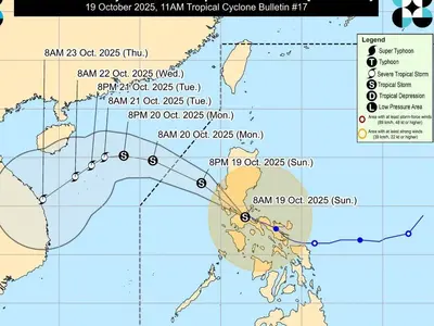
TRACK AND INTENSITY OUTLOOK
Tropical Depression “ROSAL” is forecast to decelerate while moving north northwestward or northward in the near-term before turning northeastward for the remainder of the forecast period.
“ROSAL” is forecast to intensify while moving over the Philippine Sea and may reach tropical storm in the next 24 hours. However, due to the interaction with the Northeast Monsoon, the tropical cyclone may weaken into tropical depression on Monday and become a remnant low on Tuesday.