A LOW-PRESSURE area (LPA) over the West Philippine Sea has intensified into Tropical Depression Fabian, the Philippine Atmospheric, Geophysical, and Astronomical Services Administration (Pagasa) announced Friday morning.
At 145 kilometers west of Sinait, Ilocos Sur, Fabian is packing maximum sustained winds of 45 kilometers per hour (kph) with gusts of up to 55 kph. It is moving northwestward at 15 kph and is expected to leave the Philippine Area of Responsibility (PAR) later today.
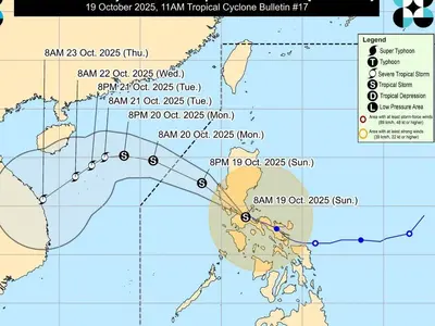
Meanwhile, Pagasa is monitoring Tropical Storm Podul, currently located 2,550 kilometers east of Extreme Northern Luzon. Podul is forecast to enter PAR late Sunday or early Monday and will be given the local name Gorio. There is a possibility that Podul will intensify into a typhoon before making landfall. Pagasa projects that Gorio will generally move westward and head towards southern Taiwan by midweek of next week.