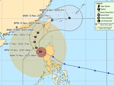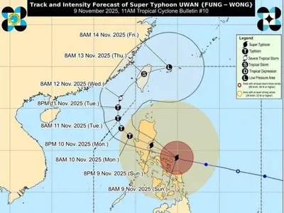
THE Philippine Atmospheric, Geophysical and Astronomical Services Administration (Pagasa) said Monday that the low-pressure area (LPA) nearing the Philippine area of responsibility (PAR) has strengthened into a tropical depression.
Based on the 11 a.m. bulletin of the Pagasa, the tropical depression was last located 1,540 kilometers east of southeastern Mindanao, packing maximum sustained winds of 45 kilometers per hour (kph) and gustiness of 55 kph.
The cyclone was moving eastward at 20 kph.
“On the track forecast, the tropical depression may enter the PAR region late Wednesday,” Pagasa said in an advisory sent to reporters.
It will be named “Kabayan” once it enters the PAR, it added.
As of the latest weather bulletin, the tropical depression was seen to follow a south-southwestward movement in the next 12 hours before turning west-southwestward.
It will then move west-northwestward while gradually accelerating as it nears the eastern boundary of the PAR, according to Pagasa.
“It will then turn further west-northwestward or westward on Thursday (16 November) on a steady pace towards the coast of eastern Visayas,” the state weather agency also said.