Skip to content
Metro Sun Daily

Metro Sun Daily

REAL NEWS * REAL TIME

  • Home
  • Nation
  • Metro
  • Regions
  • Global
  • Feature
  • Entertainment
  • Opinion
  • Business
  • Sports
  • Weather
  • OFW
  • Oddnews
  • Front Page
Senate Online
  • Weather

‘Isang’ slightly decelerates, continues to cross Quirino province

admin August 22, 2025

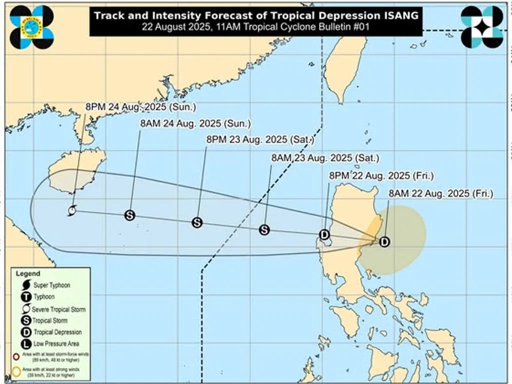
LOCATION of Center (4:00 PM): The center of Tropical Depression ISANG was estimated based on all available data including those from Baler Doppler Weather Radar in the vicinity of Aglipay, Quirino (16.5°N, 121.6°E).

Intensity: Maximum sustained winds of 55 km/h near the center, gustiness of up to 90 km/h, and central pressure of 1002 hPa

Present Movement: West northwestward at 15 km/h

Extent of Tropical Cyclone Winds: Strong winds extend outwards up to 200 km from the center

TROPICAL CYCLONE WIND SIGNALS (TCWS) IN EFFECT

TCWS No. 1

Wind threat: Strong winds

Luzon

Cagayan, Isabela, Quirino, Nueva Vizcaya, Apayao, Kalinga, Abra, Mountain Province, Ifugao, Benguet, Ilocos Norte, Ilocos Sur, La Union, Pangasinan, Aurora, and the northern portion of Nueva Ecija (Lupao, Carranglan, Pantabangan, San Jose City)

Warning lead time: 36 hours

Range of wind speeds: 39 to 61 km/h (Beaufort 6 to 7)

Potential impacts of winds: Minimal to minor threat to life and property

OTHER HAZARDS AFFECTING LAND AREAS

Heavy Rainfall Outlook

Refer to Weather Advisory No. 5 issued at 5:00 PM today for the heavy rainfall outlook due to ISANG and the Southwest Monsoon.

Severe Winds

The wind signals warn the public of the general wind threat over an area due to the tropical cyclone. Local winds may be slightly stronger/enhanced in coastal and upland/mountainous areas exposed to winds. Winds are less strong in areas sheltered from the prevailing wind direction.

• Minimal to minor impacts from strong winds are also possible within any of the areas under Wind Signal No. 1.

The Southwest Monsoon slightly enhanced by ISANG will bring strong to gale-force gusts over the following areas (especially in coastal and upland areas exposed to winds):

• Today: Zambales, Bataan, Metro Manila, CALABARZON, MIMAROPA, Camarines Norte, Camarines Sur, Catanduanes, Burias Island, Western Visayas, Negros Island Region, Central Visayas, Dinagat Islands, Southern Leyte, Surigao del Norte, and Camiguin.

• Tomorrow (23 August): Batanes, Cagayan, Ilocos Region, Cordillera Administrative Region, Zambales, Bataan, Tarlac, Pampanga, Bulacan, Metro Manila, Cavite, Rizal, Palawan, Occidental Mindoro, Romblon, Burias Island, Camarines Sur.

• Sunday (24 August): Kalayaan Islands.

HAZARDS AFFECTING COASTAL WATERS

24-Hour Sea Condition Outlook

No Gale Warning hoisted at this time.

Up to rough seas over the following coastal waters:

• Up to 3.0 m: The seaboards of Batanes and Cagayan.

• Mariners of small seacrafts, including all types of motorbancas, are advised not to venture out to sea under these conditions, especially if inexperienced or operating ill-equipped vessels.

Up to moderate seas over the following coastal waters:

• Up to 2.5 m: The seaboards of Isabela, Ilocos Norte, and Ilocos Sur.

• Up to 2.0 m: The seaboards of Aurora and Zambales; the western seaboards of Bataan and Lubang Island.

• Mariners of motorbancas and similarly-sized vessels are advised to take precautionary measures while venturing out to sea and, if possible, avoid navigation under these conditions.

TRACK AND INTENSITY OUTLOOK

• Tropical Depression ISANG will traverse Northern Luzon and emerge over the West Philippine Sea tonight, and eventually exit the Philippine Area of Responsibility tomorrow (23 August) morning or afternoon.

• ISANG is forecast to intensify into a tropical storm tomorrow morning and may reach severe tropical storm category while approaching the waters south of Hainan, China. However, intensification into a tropical storm at a much earlier time (e.g., several hours after emerging over the West Philippine Sea) is not ruled out.

Considering these developments, the public and disaster risk reduction and management offices concerned are advised to take all necessary measures to protect life and property. Persons living in areas identified to be highly or very highly susceptible to these hazards are advised to follow evacuation and other instructions from local officials. For heavy rainfall warnings, thunderstorm/rainfall advisories, and other severe weather information specific to your area, please monitor products issued by your local PAGASA Regional Services Division.

Tags: isang pagasa quirino

Post navigation

Previous Villar Land Holdings fined P12M by SEC for late financial report
Next Speaker backs 50% student MRT-LRT transport discount

Related Stories

Super Typhoon Nando threatens N Luzon; Signal No. 5 raised
  • Weather

Super Typhoon Nando threatens N Luzon; Signal No. 5 raised

Classes, gov’t offices suspended in Metro Manila, other areas on Monday due to ‘Nando’
  • Weather

Classes, gov’t offices suspended in Metro Manila, other areas on Monday due to ‘Nando’

‘Nando’ rapidly intensifies, Super Typhoon status possible by Monday
  • Weather

‘Nando’ rapidly intensifies, Super Typhoon status possible by Monday

ODDNEWS

  • Security guard returns lost P1.5M bracelet
  • Sole survivor of Air India crash recounts escape
  • Chinese woman’s dramatic pregnancy transformations go viral
  • Man shot by his own dog while sleeping in Memphis
  • Human arm found inside shark’s stomach shocks fishermen, residents
  • Tragic fishing accident: Fisherman dies after fish enters throat in Cebu

Source: USD/PHP @ Tue, 23 Sep.

Weather

Manila
-º
-
-
Forecast
Rain chance-
-
-
Forecast
Rain chance-
-
-
Forecast
Rain chance-
Manila weather

Latest Comments

  1. 독학기숙학원 on Senate reclaims custody of Brice Hernandez amid safety concerns
  2. good citizen on Santos eyes multi-pronged strategy to solve Las Piñas traffic woes

  • Front Page
  • Home
  • About Us
  • Donation
  • Privacy Policy
  • Contact
  • Facebook
  • Twitter
  • Instagram
  • Pinterest
  • Tumblr
  • Linkedin
©2025 MetroSunDaily. All rights reserved. | DarkNews by AF themes.
We use cookies on our website to give you the most relevant experience by remembering your preferences and repeat visits. By clicking “Accept”, you consent to the use of ALL the cookies.
Do not sell my personal information.
Cookie SettingsAccept
Manage consent

Privacy Overview

This website uses cookies to improve your experience while you navigate through the website. Out of these, the cookies that are categorized as necessary are stored on your browser as they are essential for the working of basic functionalities of the website. We also use third-party cookies that help us analyze and understand how you use this website. These cookies will be stored in your browser only with your consent. You also have the option to opt-out of these cookies. But opting out of some of these cookies may affect your browsing experience.
Necessary
Always Enabled
Necessary cookies are absolutely essential for the website to function properly. These cookies ensure basic functionalities and security features of the website, anonymously.
CookieDurationDescription
cookielawinfo-checkbox-analytics11 monthsThis cookie is set by GDPR Cookie Consent plugin. The cookie is used to store the user consent for the cookies in the category "Analytics".
cookielawinfo-checkbox-functional11 monthsThe cookie is set by GDPR cookie consent to record the user consent for the cookies in the category "Functional".
cookielawinfo-checkbox-necessary11 monthsThis cookie is set by GDPR Cookie Consent plugin. The cookies is used to store the user consent for the cookies in the category "Necessary".
cookielawinfo-checkbox-others11 monthsThis cookie is set by GDPR Cookie Consent plugin. The cookie is used to store the user consent for the cookies in the category "Other.
cookielawinfo-checkbox-performance11 monthsThis cookie is set by GDPR Cookie Consent plugin. The cookie is used to store the user consent for the cookies in the category "Performance".
viewed_cookie_policy11 monthsThe cookie is set by the GDPR Cookie Consent plugin and is used to store whether or not user has consented to the use of cookies. It does not store any personal data.
Functional
Functional cookies help to perform certain functionalities like sharing the content of the website on social media platforms, collect feedbacks, and other third-party features.
Performance
Performance cookies are used to understand and analyze the key performance indexes of the website which helps in delivering a better user experience for the visitors.
Analytics
Analytical cookies are used to understand how visitors interact with the website. These cookies help provide information on metrics the number of visitors, bounce rate, traffic source, etc.
Advertisement
Advertisement cookies are used to provide visitors with relevant ads and marketing campaigns. These cookies track visitors across websites and collect information to provide customized ads.
Others
Other uncategorized cookies are those that are being analyzed and have not been classified into a category as yet.
SAVE & ACCEPT