HAZARDS AFFECTING LAND AREAS
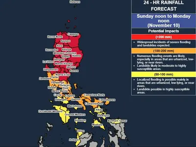
Heavy Rainfall Outlook
Forecast accumulated rainfall on Monday
50-100 mm: Catanduanes
In addition, EGAY may also enhance the Southwest Monsoon during the weekend and into next week:
Tomorrow: Occasional rains possible over Western Visayas and Occidental Mindoro.
Monday: Occasional rains likely over Western Visayas, Occidental Mindoro, and the northern portion of Palawan including Calamian Islands.
A Weather Advisory may be issued for these areas in anticipation of the potential heavy rainfall.
Forecast rainfall are generally higher in elevated or mountainous areas. Under these conditions, flooding and rain-induced landslides are possible, especially in areas that are highly or very highly susceptible to these hazard as identified in hazard maps and in localities that experienced considerable amounts of rainfall for the past several days.
Severe Winds
In anticipation of the arrival of strong breeze to near-gale conditions associated with EGAY, Wind Signals may be hoisted in some areas in Bicol Region and Eastern Visayas.
The enhanced Southwest Monsoon may bring gusty conditions over the following areas (especially in coastal and upland/mountainous areas exposed to winds:
Today: The western and southern portions of Visayas, the northern portions of Northern Mindanao and Caraga, Romblon, and Masbate.
Tomorrow: Most of Visayas and MIMAROPA and the northern portions of Northern Mindanao and Caraga.
Monday: MIMAROPA, most of Visayas, the northern portions of Northern Mindanao and Caraga, and portions of Zamboanga Peninsula.
HAZARDS AFFECTING COASTAL WATERS
In the next 24 hours, EGAY may bring moderate to rough seas (2.5 to 4.0 m) over the eastern seaboards of Southern Luzon, Visayas, and Mindanao. Mariners of small seacrafts are advised to take precautionary measures when venturing out to sea. If inexperienced or operating ill-equipped vessels, avoid navigating in these conditions.
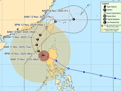
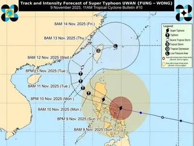
TRACK AND INTENSITY OUTLOOK
EGAY is forecast to track generally west northwestward or westward today and tomorrow before turning northwestward for the remainder of the forecast period. The current forecast track indicates that EGAY will remain offshore over the Philippine Sea. However, the forecast confidence cone indicates that a landfall scenario over the northern portion of Northern Luzon is not ruled out at this time. Analysis of available meteorological data indicates that considerable shifts in its track forecast remain possible in succeeding bulletins.
EGAY is forecast to intensify into a severe tropical storm in the next 12 hours. Through the forecast period, this tropical cyclone will continue to steadily intensify. It may reach peak at super typhoon category on Tuesday or Wednesday while over the Philippine Sea east of Extreme Northern Luzon.
Location of Eye/center
The center of Tropical Storm EGAY was estimated based on all available data at 685 km East of Virac, Catanduanes (14.3 °N, 130.5 °E )