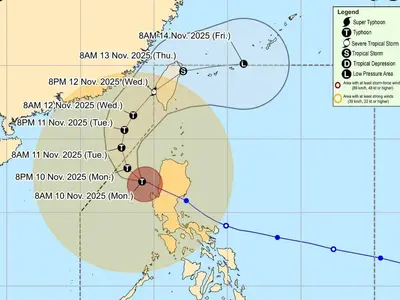
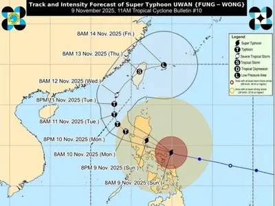
AT 3:00 AM today, the center of the eye of Typhoon “EGAY” {DOKSURI} was estimated based on all available data at 570 km East of Baler, Aurora (15.2°N, 126.9°E) with maximum sustained winds of 140 km/h near the center and gustiness of up to 170 km/h.
It is moving Westward at 15 km/h. Southwest Monsoon affecting Southern Luzon, Visayas, and Mindanao.
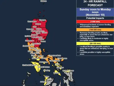
Heavy Rainfall Outlook
Forecast accumulated rainfall from today to tomorrow noon
· 50-100 mm: Cagayan, Catanduanes, Camarines Sur, Camarines Norte, and the northern portion of Sorsogon
Forecast accumulated rainfall tomorrow noon to Wednesday noon
· Above 200 mm: Batanes, Cagayan, Ilocos Norte, Ilocos Sur, northern portion of Apayao, Abra, and the northern portion of La Union
· 100-200 mm: the northern and eastern portion of Isabela, the rest of Apayao, the rest of La Union, Mt. Province, Benguet, and the western portion of Pangasinan
· 50-100 mm: the rest of Cordillera Administrative Region, the rest of Pangasinan, and Zambales
Forecast accumulated rainfall on Wednesday noon to Thursday noon
· Above 200 mm: Batanes, Babuyan Islands, Ilocos Norte, the northwestern portion of Abra
· 100-200 mm: The northern portion of mainland Cagayan, Apayao, the rest of Abra, and Ilocos Sur,
· 50-100 mm: The rest of mainland Cagayan, Kalinga, the western portion of Mountain Province, Benguet, La Union, and Pangasinan.
Forecast rainfall are generally higher in elevated or mountainous areas. Under these conditions, flooding and rain-induced landslides are highly likely especially in areas that are highly or very highly susceptible to these hazard as identified in hazard maps and in localities that experienced considerable amounts of rainfall for the past several days.
In addition, EGAY may also enhance the Southwest Monsoon, bringing occasional to monsoon rains over the western portions of Central Luzon, Southern Luzon, and Visayas in the next three days. For more information, refer to Weather Advisory #4 for Southwest Monsoon issued at 11:00 AM today and the 24-Hour Public Weather Forecast and Outlook at 4:00 AM today.
Severe Winds
Minor to moderate impacts from gale-force winds are possible within any of the areas where Wind Signal No. 2 are in effect. Minimal to minor impacts from strong winds are also possible within any of the areas where Wind Signal No.1 is hoisted. Current forecast scenario shows that the highest wind signal that may be hoisted will be Wind Signal No. 4 or 5 (e.g., typhoon-force wind threat).
EGAY and the enhanced Southwest Monsoon may also bring gusty conditions over the following areas not under any Wind Signal, especially in coastal and upland/mountainous areas exposed to winds:
· Today: The rest of Visayas and MIMAROPA, and the northern portions of Zamboanga Peninsula, Northern Mindanao, and Caraga.
· Tomorrow: The rest of Luzon and Visayas, Zamboanga Peninsula, Basilan, Sulu, Tawi-Tawi, and the northern portion of Northern Mindanao and Dinagat Islands.