AS Tropical Storm “Uwan” makes its way towards the Philippines, state weather bureau PAGASA has hoisted Signal No. 1 in 21 areas nationwide.
According to PAGASA’s tropical cyclone bulletin released on Friday, the following areas are now under Signal No. 1, experiencing winds of 39-61 km/h within the next 36 hours:
- The southeastern portion of Quezon (Tagkawayan, Guinayangan, Calauag, Lopez, Buenavista, Catanauan, Mulanay, San Narciso, San Andres, San Francisco)
- The eastern portion of Romblon (Cajidiocan, San Fernando, Magdiwang)
- Camarines Norte
- Camarines Sur
- Catanduanes
- Albay
- Sorsogon
- Masbate
- Northern Samar
- Eastern Samar
- Samar
- Biliran
- Leyte
- Southern Leyte
- The northern and central portions of Cebu (Medellin, Daanbantayan, City of Bogo, Tabogon, San Remigio, Tabuelan, Borbon, Sogod, Tuburan, Catmon, Carmen, Danao City, Compostela, Liloan, Consolacion, Lapu-Lapu City, Mandaue City, Cordova, Asturias, Cebu City, Balamban, City of Talisay, Toledo City, Minglanilla) including Bantayan and Camotes Islands
- The northeastern portion of Bohol (Getafe, Talibon, Buenavista, Trinidad, San Miguel, Ubay, Alicia, Mabini, Bien Unido, Pres. Carlos P. Garcia)
- The northern portion of Negros Occidental (City of Escalante, Toboso, Sagay City, Cadiz City, Calatrava, Manapla)
- The northeastern portion of Capiz (President Roxas, Pilar, Panay, Pontevedra)
- The northeastern portion of Iloilo (Carles, Estancia, Balasan, San Dionisio, Concepcion, Batad, Sara, Ajuy)
- Dinagat Islands
- Surigao del Norte
PAGASA warned that “minimal to minor impacts from strong winds are possible within any of the areas under Wind Signal No. 1,” and that the highest wind signal that will likely be hoisted throughout its passage is Wind Signal No. 5.
As of the latest update, Tropical Storm “Uwan” was located 1,175 kilometers east of Eastern Visayas, packing maximum sustained winds of 110 kph and gustiness of up to 135 kph. While currently outside the PAR, it is expected to enter between Friday and Saturday early morning.
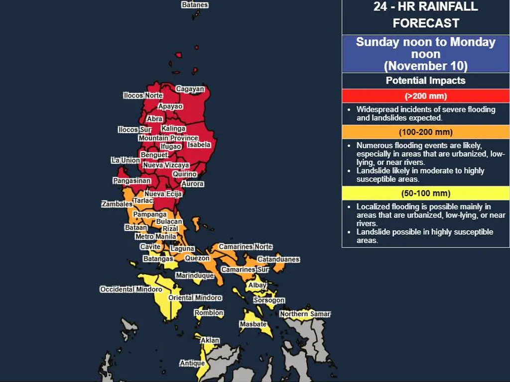
PAGASA forecasts that “Uwan” will make landfall over the southern portion of Isabela or the northern portion of Aurora on Sunday late evening or Monday early morning. The storm is predicted to reach typhoon category within the next 24 hours and potentially strengthen into a super typhoon by Saturday evening or Sunday morning.
The weather bureau also cautioned about the possibility of life-threatening storm surges and coastal-related flooding, particularly in Northern Luzon and the east coast of Central and Southern Luzon. Gale warnings may be raised over Luzon, Visayas, and Caraga Region on Friday night or Saturday morning.
metrosundaily

